The 3D Tree Inventory of urban trees in the Municipality of Siena began this morning, Wednesday, May 7. The project, named "Digital Twins," will allow the creation of virtual models of the city's trees and green areas to improve the management of the arboreal heritage, increase biodiversity, and remotely monitor the health status of the plants, thanks to innovative technologies such as satellite mapping and drones.
"Through the launch of the 'Digital Twins' program," emphasizes the Councillor for the Environment and Green Area Maintenance, Barbara Magi, "we will use advanced tools to ensure more efficient and timely management of green areas, to anticipate critical issues and safeguard our environmental heritage. The adoption of cutting-edge technologies will allow us to constantly monitor the health of the plants, intervening promptly when necessary and making Siena a city more prepared to face climate changes. What begins today is an ambitious project that makes an important contribution toward a smarter, safer, and more sustainable management of public green spaces."
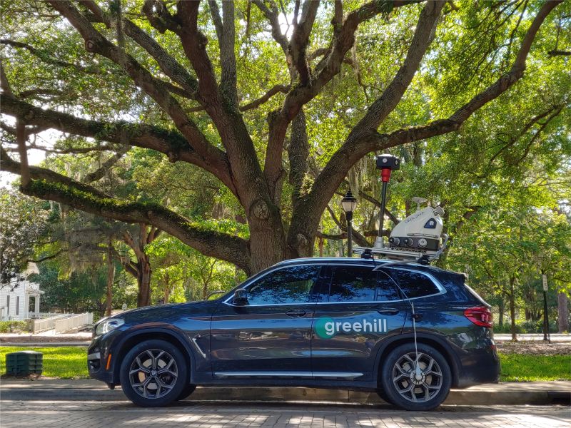
The survey, which started this morning from the roundabout between Sr 222 Chiantigiana and Via Montarioso, is being conducted using Greehill's innovative technology, in collaboration with R3GIS, the official partner for Italy and Italian-speaking Switzerland. Greehill currently represents the most advanced standard in urban green surveying, thanks to a unique combination of laser scanning, artificial intelligence, and machine learning. Each tree is transformed into a digital twin: a georeferenced 3D model accompanied by biometric data, high-resolution images, and structural information. These data will enable the Municipality of Siena to accurately monitor the phytosanitary status of the trees, plan interventions, and optimize resources.
"With this project," says Marco Cicala, COO of R3GIS, "we are not just taking a tree census, but we are laying the foundations for a more resilient, transparent, and data-driven urban management. Each tree can be monitored over time, and it will be possible to consult its digital twin to evaluate it based on scientific data."
The survey launched in Siena follows experiences already active in cities like Padua and Parma, where digital twins have already been successfully used to improve safety, respond more quickly to reports, and support urban planning based on scientific data. The project involves multi-year monitoring, which does not stop at the initial data collection but ensures constant updates over time, confirming the commitment of the municipal administration to adopt a proactive and strategic approach to green management.